Technology
WORLD'S FIRST 10-METER RESOLUTION GLOBAL FOREST MONITORING PLATFORM
LAUNCHED BY TerraPulse
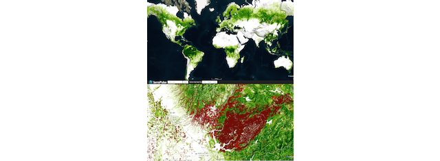
Forest cover/loss in western Sierra Nevada, Ca.* (Source: terraPulse)
USPA NEWS -
TerraPulse, Inc., the green technology startup that introduced the world's first high-resolution satellite map of global tree canopy cover in 2013, announced on February 8, the company has again broken the record for resolution in global mapping.
TerraPulse, Inc., the green technology startup that introduced the world's first high-resolution satellite map of global tree canopy cover in 2013, announced on February 8, the company has again broken the record for resolution in global mapping.
The company's terraView land-monitoring platform will now host tree canopy, deforestation, and other forest-monitoring indices at 10-meter spatial resolution from 2017 to present, allowing detection and monitoring of forest change globally at the highest spatial and temporal resolution possible to date.
The company's terraView land-monitoring platform will now host tree canopy, deforestation, and other forest-monitoring indices at 10-meter spatial resolution from 2017 to present, allowing detection and monitoring of forest change globally at the highest spatial and temporal resolution possible to date.
Applying terraPulse's artificial intelligence (AI) to the European Space Agency's publicly available global archive of satellite images, the technology allows measurement and monitoring of natural assets from the entire globe down to individual forest stands. The unprecedented detail enables landowners, foresters, and investors to participate in emerging carbon and biodiversity markets by providing intelligence on the state and changes of what is increasingly becoming known as "natural capital."
With climate and land-use change posing growing existential threats to biodiversity, monitoring the global biosphere is more important than ever," says Joseph Sexton, Chief Scientist and Co-Founder of terraPulse. "Detecting forest activity at 9 times the previous scale will overcome a major obstacle to sustainable development and accelerate the resilience of rural economies to global change."
Sexton describes terraPulse as a "Bloomberg terminal for the biosphere." The platform's new set of global indices enables:
* Detection of deforestation and forest degradation
* Quantification of carbon stocks and changes
* Prediction of fire risk
* Analysis of biodiversity habitat and wildlife movement
* Detection of deforestation and forest degradation
* Quantification of carbon stocks and changes
* Prediction of fire risk
* Analysis of biodiversity habitat and wildlife movement
Min Feng, terraPulse's Chief Technology Officer and Co-Founder, described the achievement as two major milestones: "This sets the new standard in spatial scale, and combined with terraPulse's entire historical record, it is the only map series spanning nearly four decades of forest change."
*Photo cover: Forest cover/loss in the western Sierra Nevada, California (USA): The terraPulse tree canopy cover map (2021) is displayed in green and forest losses between 2017-2021 are in shades of red. The forest loss shown can be attributed to two large fires: the Camp Fire (153,336 acres, November 8-25 2018) and the North Complex Fire (318,935 acres, August 17-December 3, 2020). The Camp Fire was the costliest disaster of 2018, causing $16.65 billion in property damage, 52,000 evacuations, and 85 deaths.
Source: TerraPulse
Ruby BIRD
http://www.portfolio.uspa24.com/
Yasmina BEDDOU
http://www.yasmina-beddou.uspa24.com/
Liability for this article lies with the author, who also holds the copyright. Editorial content from USPA may be quoted on other websites as long as the quote comprises no more than 5% of the entire text, is marked as such and the source is named (via hyperlink).